Right-of-Way
Right of Way Preservation
Right of Way Preservation
Acquisition of an area of land, through dedication or easement, needed to accommodate the future widening of the roadway or a variety of other functions.
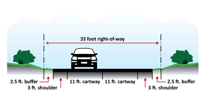
Common suburban and rural rights-of-way in Chester County are thirty-three feet. Right-of-Way elements include the cartway, shoulder and buffer area. The buffer provides an area for: snow storage, guide rails, sight distance, drainage, utilities, side slope, and pedestrian facilities. Right-of-way widths should vary according to the intended function of the road. Right-of-way preservation should include allowances for bus passenger facilities, including ADA accessible loading pads, bus shelters and ADA-compliant sidewalk connections, where appropriate.

Most preservation actions come under the authority of municipalities. Municipalities should:
- identify corridors in need of preservation;
- coordinate preservation efforts with other local jurisdictions; and,
- identify local resources for right-of-way acquisition and assess their availability in cases where advance acquisition appears appropriate.
The amount of required right-of-way should be based on design criteria listed in this document.
Municipalities may preserve rights-of-way for future use through the Pennsylvania Municipalities Planning Code, particularly in:
- Article III, Comprehensive Plan;
- Article IV, Official Map;
- Article V, Subdivision and Land Development; and,
- Article VI, Zoning.
During the times of diminishing tax bases and increasing costs of infrastructure and services, preserving rights-of-way for future use is important, especially when attempting to keep costs of acquisitions to a minimum.
Ultimate Right of Way
Ultimate Right of Way
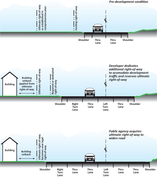
An area of land beyond the legal or dedicated right-of-way needed to accommodate the future widening of the roadway, measured from the centerline of the cartway.
With some land developments, additional right-of-way is necessary to mitigate traffic patterns caused by trips generated by the development. This is generally referred to as "required" or "dedicated" right-of-way. In some cases, additional road widening is necessary to accommodate the greater public interest. While it is not the responsibility of the developer to accommodate the long term public need, it is in the best interest of the developer to make the ultimate right-of-way available to the public for eventual acquisition and use. This technique will preserve property and building values when the roadway is widened. By precluding buildings and structures within the ultimate right-of-way, the cost of public acquisition is reduced, making the highway project more feasible.
The ultimate right-of-way is owned and maintained by the property owner with the understanding that the public may need to purchase it in the future. This provision can only be applied by a municipality through the subdivision and land development ordinance. The ultimate right-of-way needs to be shown on the subdivision plan and recorded on the deed.

Right of Way Width
Right of Way Width
An area of land, measured from the centerline of the cartway that can be used by the public for travel or to locate utilities. Existing right-of-way width can be determined through highway right-of-way plans or deeds for individual parcels.
A right-of-way must provide enough width for cartways, medians, shoulders, landscaping strips, sidewalks, utility strips, sign/signal pole placement, and necessary outer slopes and may be used for the future widening and channelization of a street. The width of the right-of-way varies by the functional classification of the roadway. According to the Urban Land Institute's Residential Streets: Right-of-way width allowance for future street widening should be unnecessary in most well-planned residential neighborhoods. A need for future widening allowance on collector streets could be argued because of their through characteristic, but widening of a residential collector street will change the character of a neighborhood and increase the attractiveness of the street to through traffic. Such widening is viewed as undesirable — so every reasonable planning strategy should be utilized to preclude future widening needs for most residential area collector streets. By example Residential Streets recommends that the lowest right-of-way width for a lower order local road may be 24 feet. The best strategy usually is to assure sufficient arterial street capacity outside of the neighborhood to accommodate foreseeable traffic needs.
Recommendations
- Identify and implement a right-of-way preservation plan through the use of the ultimate right-of-way technique.
- Designate ultimate rights-of-way on all municipal roads which would reflect a built-out scenario.
- The ultimate right-of-way could:
- be used in an overlay zoning district along selected corridors; and
- be used in conjunction with setbacks to provide adequate distances between the roadway and structures. See SETBACKS design element.
- Credit the area set aside for the ultimate right-of-way in the calculation of overall density or square footage.
- Existing vegetation within the ultimate right-of-way line can remain. New landscaping should be focused as close to the ultimate right-of-way line as possible.
- The Chester County Planning Commission recommends the following inclusion on future subdivision and land development plans:
"The lots with frontage on State Route - shall be conveyed under and subject to a reservation of title granting unto the municipality the right and option of a continuing offer of dedication without further consideration of the right to accept all or any part of the lands lying within the area from the affected lot line to the proposed right-of-way line. This frontage area may be accepted at any time or from time to time by the municipality for use thereof for highway improvements to be made by them at its sole cost and expense. This area is not dedicated by this plan."
Suggested Right-of-Way Widths (feet)
| Land Use Context | |||
|---|---|---|---|
| Functional Classfication | Rural | Suburban | Urban |
| Major Arterial | 150 | 150 | 100 | Minor Arterial | 100 | 100 | 80 | Major Collector | 80 | 80 | 80 | Minor Collector | 80 | 80 | 80 | Primary Distributor | 60 | 60 | 50 | Secondary Distributor | 50 | 50 | 50 | Local Road* | 50 | 50 | 50 | Local Road** | 33 | 33 | 33 |
*Average Daily Traffic is more than 100 vehicles
**Average Daily Traffic is less than 100 vehicles


